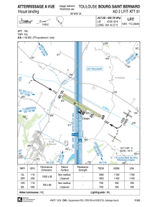
VAC chart of LFIT
 Satellite view of LFIT

Satellite view of LFIT
Sorry, we have no imagery here.
Sorry, we have no imagery here.
Sorry, we have no imagery here.
Sorry, we have no imagery here.
Sorry, we have no imagery here.
Sorry, we have no imagery here.


LFIT - Toulouse Bourg Saint Bernard
Located in , France
ICAO - LFIT, IATA -
Data provided by AirmateGeneral information
Coordinates: N43°36'40" E1°43'27"
Elevation is 526 feet MSL.
Magnetic variation is 1.06° East View others Airports in Midi-Pyrénées
Operational data
Special qualification required
Current time UTC: 09:20:45
Current local time:
Weather at : LFBO - Toulouse Blagnac ( 29 km )
METAR: LFBO 210900Z AUTO 30005KT 250V020 9999 OVC020 15/11 Q1021 NOSIG
TAF: TAF AMD LFBO 210813Z 2108/2212 28012KT 9999 BKN016 BECMG 2109/2111 BKN035 PROB30 TEMPO 2115/2118 -SHRA SCT030TCU PROB40 TEMPO 2200/2208 -RA BKN013
Communications frequencies: [VIEW]
Runways:
| RWY identifier | QFU | Length (ft) | Width (ft) | Surface | LDA (ft) |
| 12R | 120° | 2297 | 197 | GRASS | 2297 |
| 30L | 300° | 2297 | 197 | GRASS | 2297 |
| 12L | 120° | 3937 | 164 | GRASS | 3609 |
| 30R | 300° | 3937 | 164 | GRASS | 3609 |
Airport contact information
Address: France
