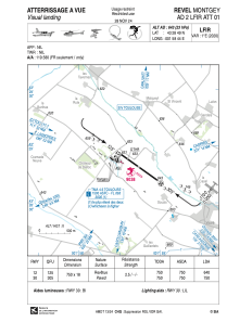
VAC chart of LFIR
 Satellite view of LFIR
Satellite view of LFIR
Sorry, we have no imagery here.
Sorry, we have no imagery here.
Sorry, we have no imagery here.
Sorry, we have no imagery here.
Sorry, we have no imagery here.
Sorry, we have no imagery here.


LFIR - Revel Montgey
Located in , France
ICAO - LFIR, IATA -
Data provided by AirmateGeneral information
Coordinates: N43°28'49" E1°58'44"
Elevation is 643 feet MSL.
Magnetic variation is 1.13° East View others Airports in Midi-Pyrénées
Operational data
Special qualification required
Current time UTC: 21:38:58
Current local time:
Weather at : LFCK - Castres Mazamet ( 26 km )
METAR: LFCK 222130Z AUTO 29009KT CAVOK 14/09 Q1020
TAF: TAF LFCK 221700Z 2218/2303 29011KT 9999 BKN048 BECMG 2222/2224 VRB03KT BECMG 2300/2302 BKN012 BKN030
Communications frequencies: [VIEW]
Runways:
| RWY identifier | QFU | Length (ft) | Width (ft) | Surface | LDA (ft) |
| 12 | 126° | 2461 | 59 | ASPH | 2100 |
| 30 | 306° | 2461 | 59 | ASPH | 2461 |
Airport contact information
Address: France
