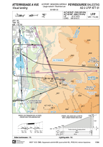
VAC chart of LFIP
 Satellite view of LFIP

Satellite view of LFIP
Sorry, we have no imagery here.
Sorry, we have no imagery here.
Sorry, we have no imagery here.
Sorry, we have no imagery here.
Sorry, we have no imagery here.
Sorry, we have no imagery here.


LFIP - Peyresourde Balestas
Located in , France
ICAO - LFIP, IATA -
Data provided by AirmateGeneral information
Coordinates: N42°47'49" E0°26'2"
Elevation is 5193 feet MSL.
Magnetic variation is 0.74° East View others Airports in Midi-Pyrénées
Operational data
Special qualification required
Current time UTC: 04:27:33
Current local time:
Weather at : LFBT - Tarbes Lourdes Pyrenees ( 56 km )
METAR: LFBT 200400Z AUTO 26016KT 9999 BKN021 BKN026 OVC035 14/11 Q1018 TEMPO 27015G25KT 4000 RA BKN008
TAF: TAF LFBT 192300Z 2000/2024 26009KT 9999 BKN020 PROB40 TEMPO 2000/2008 27015G25KT 4000 RA BKN008 BECMG 2008/2010 SCT030 BKN055 PROB40 TEMPO 2008/2014 -SHRA SCT035TCU BECMG 2015/2017 CAVOK
Communications frequencies: [VIEW]
Runways:
| RWY identifier | QFU | Length (ft) | Width (ft) | Surface | LDA (ft) |
| 09 | 94° | 1542 | 66 | ASPH | |
| 27 | 274° | 1542 | 66 | ASPH |
Airport contact information
Address: France
