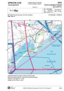
VAC chart of LFH456
 Satellite view of LFH456
Satellite view of LFH456
Sorry, we have no imagery here.
Sorry, we have no imagery here.
Sorry, we have no imagery here.
Sorry, we have no imagery here.
Sorry, we have no imagery here.


LFH456 - Sete Helistation Des Hopitaux Du Bassin De Thau
Located in , France
ICAO - , IATA -
Data provided by AirmateGeneral information
Coordinates: N43°24'28" E3°40'11"
Elevation is 132 feet MSL.
Magnetic variation is 1.56° East View others Airports in Languedoc-Roussillon
Operational data
Special qualification required
Current time UTC: 18:05:09
Current local time:
Weather at : LFMU - Beziers Vias ( 27 km )
METAR: LFMU 031730Z AUTO 07003KT CAVOK 12/07 Q1024 NOSIG
TAF: TAF LFMU 031400Z 0315/0415 09010KT 9999 FEW030 BKN050 BECMG 0318/0320 02004KT BECMG 0409/0411 08010KT
Communications frequencies: [VIEW]
Runways:
Airport contact information
Address: France
Satellite view of LFH456
Sorry, we have no imagery here.
Sorry, we have no imagery here.
Sorry, we have no imagery here.
Sorry, we have no imagery here.
Sorry, we have no imagery here.