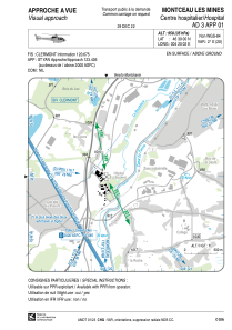
VAC chart of LFH301
 Satellite view of LFH301

Satellite view of LFH301
Sorry, we have no imagery here.
Sorry, we have no imagery here.
Sorry, we have no imagery here.
Sorry, we have no imagery here.
Sorry, we have no imagery here.
Sorry, we have no imagery here.


LFH301 - Montceau Les Mines Centre Hospitalier
Located in , France
ICAO - , IATA -
Data provided by AirmateGeneral information
Coordinates: N46°39'0" E4°20'2"
Elevation is 958 feet MSL.
Magnetic variation is 1.67° East View others Airports in Burgundy
Operational data
Special qualification required
Current time UTC: 01:58:34
Current local time:
Weather at : LFLN - Saint Yan ( 36 km )
METAR: LFLN 250130Z AUTO 18002KT CAVOK 11/08 Q1019
TAF: TAF LFLN 241700Z 2418/2503 VRB03KT CAVOK
Communications frequencies: [VIEW]
Runways:
Airport contact information
Address: France
Satellite view of LFH301
Sorry, we have no imagery here.
Sorry, we have no imagery here.
Sorry, we have no imagery here.
Sorry, we have no imagery here.
Sorry, we have no imagery here.
Sorry, we have no imagery here.