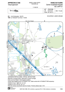
VAC chart of LFH173
 Satellite view of LFH173

Satellite view of LFH173
Sorry, we have no imagery here.
Sorry, we have no imagery here.
Sorry, we have no imagery here.
Sorry, we have no imagery here.
Sorry, we have no imagery here.
Sorry, we have no imagery here.


LFH173 - Rang Du Fliers Centre Hospitalier
Located in , France
ICAO - , IATA -
Data provided by AirmateGeneral information
Coordinates: N50°24'52" E1°39'47"
Elevation is 152 feet MSL.
Magnetic variation is 0.72° East View others Airports in Nord-Pas-de-Calais
Operational data
Special qualification required
Current time UTC: 16:34:59
Current local time:
Weather at : LFAT - Le Touquet Elizabeth Ii ( 11 km )
METAR: LFAT 251630Z AUTO 26014G27KT 220V290 CAVOK 15/10 Q1013
TAF: TAF LFAT 251400Z 2515/2524 26017G27KT CAVOK
Communications frequencies: [VIEW]
Runways:
Airport contact information
Address: France
Satellite view of LFH173
Sorry, we have no imagery here.
Sorry, we have no imagery here.
Sorry, we have no imagery here.
Sorry, we have no imagery here.
Sorry, we have no imagery here.
Sorry, we have no imagery here.