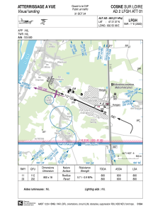
VAC chart of LFGH
 Satellite view of LFGH
Satellite view of LFGH
Sorry, we have no imagery here.
Sorry, we have no imagery here.
Sorry, we have no imagery here.
Sorry, we have no imagery here.
Sorry, we have no imagery here.
Sorry, we have no imagery here.


LFGH - Cosne Sur Loire
Located in Cosne, France
ICAO - LFGH, IATA -
Data provided by AirmateGeneral information
Coordinates: N47°21'37" E2°55'6"
Elevation is 580 feet MSL.
Magnetic variation is 1.26° East View others Airports in Burgundy
Operational data
Special qualification required
Current time UTC: 11:38:54
Current local time:
Weather at : LFOA - Avord ( 40 km )
METAR: LFOA 211130Z AUTO 25012KT 230V290 9999 BKN032 BKN140 16/09 Q1017 NOSIG
TAF: TAF AMD LFOA 211006Z 2110/2209 26012KT CAVOK TX19/2115Z TN11/2204Z TEMPO 2114/2120 26015G30KT 3000 SHRA BKN010 BKN020CB BECMG 2120/2122 32010KT BKN012 TEMPO 2200/2206 3000 DZRA BKN008
Communications frequencies: [VIEW]
Runways:
| RWY identifier | QFU | Length (ft) | Width (ft) | Surface | LDA (ft) |
| 11 | 114° | 2625 | 59 | ASPH | 2625 |
| 29 | 294° | 2625 | 59 | ASPH | 2625 |
Airport contact information
Address: Cosne France
