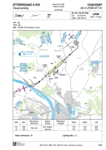
VAC chart of LFDW
 Satellite view of LFDW

Satellite view of LFDW
Sorry, we have no imagery here.
Sorry, we have no imagery here.
Sorry, we have no imagery here.
Sorry, we have no imagery here.
Sorry, we have no imagery here.
Sorry, we have no imagery here.


LFDW - Chauvigny
Located in Chauvigny, France
ICAO - LFDW, IATA -
Data provided by AirmateGeneral information
Coordinates: N46°35'0" E0°38'32"
Elevation is 442 feet MSL.
Magnetic variation is 0.64° East View others Airports in Poitou-Charentes
Operational data
Special qualification required
Current time UTC: 00:18:00
Current local time:
Weather at : LFBI - Poitiers Biard ( 26 km )
METAR: LFBI 210000Z AUTO 26005KT CAVOK 12/08 Q1020 NOSIG
TAF: TAF LFBI 202300Z 2100/2124 27005KT CAVOK PROB40 TEMPO 2102/2108 VRB03KT BKN007 PROB40 TEMPO 2112/2118 4000 SHRA SCT030CB BECMG 2114/2116 33012KT
Communications frequencies: [VIEW]
Runways:
| RWY identifier | QFU | Length (ft) | Width (ft) | Surface | LDA (ft) |
| 05 | 48° | 2428 | 262 | GRASS | 2165 |
| 23 | 228° | 2428 | 262 | GRASS | 2280 |
Airport contact information
Address: Chauvigny France
