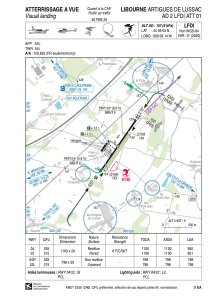
VAC chart of LFDI
 Satellite view of LFDI

Satellite view of LFDI
Sorry, we have no imagery here.
Sorry, we have no imagery here.
Sorry, we have no imagery here.
Sorry, we have no imagery here.
Sorry, we have no imagery here.
Sorry, we have no imagery here.


LFDI - Libourne Artigues De Lussac
Located in Libourne, France
ICAO - LFDI, IATA - XLR
Data provided by AirmateGeneral information
Coordinates: N44°59'3" W0°8'14"
Elevation is 157 feet MSL.
Magnetic variation is 0.49° East View others Airports in Aquitaine
Operational data
Special qualification required
Current time UTC: 01:04:23
Current local time:
Weather at : LFBD - Bordeaux Merignac ( 49 km )
METAR: LFBD 200100Z AUTO 27006KT 5000 BR FEW004 BKN012 BKN035 15/15 Q1015 NOSIG
TAF: TAF LFBD 192300Z 2000/2106 26005KT CAVOK TX24/2014Z TN15/2006Z PROB40 TEMPO 2000/2006 4000 BR BKN010 BECMG 2006/2008 30010KT TEMPO 2021/2024 BKN010
Communications frequencies: [VIEW]
Runways:
| RWY identifier | QFU | Length (ft) | Width (ft) | Surface | LDA (ft) |
| 04 | 35° | 3609 | 66 | ASPH | 3117 |
| 22 | 215° | 3609 | 66 | ASPH | 2789 |
| 04R | 35° | 2618 | 164 | GRASS | 2625 |
| 22L | 215° | 2618 | 164 | GRASS | 2625 |
Airport contact information
Address: Libourne France