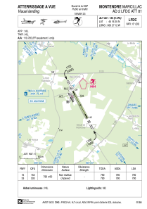
VAC chart of LFDC
 Satellite view of LFDC

Satellite view of LFDC
Sorry, we have no imagery here.
Sorry, we have no imagery here.
Sorry, we have no imagery here.
Sorry, we have no imagery here.
Sorry, we have no imagery here.
Sorry, we have no imagery here.


LFDC - Montendre Marcillac
Located in Montendre, France
ICAO - LFDC, IATA -
Data provided by AirmateGeneral information
Coordinates: N45°16'25" W0°27'12"
Elevation is 145 feet MSL.
Magnetic variation is 0.39° East View others Airports in Aquitaine
Operational data
Special qualification required
Current time UTC: 10:03:46
Current local time:
Weather at : LFBG - Cognac Chateaubernard ( 44 km )
METAR: LFBG 211000Z AUTO 26010KT 9999 FEW031 SCT046 OVC094 19/12 Q1019 NOSIG
TAF: TAF LFBG 210800Z 2109/2209 25010KT 9999 BKN030 TEMPO 2112/2115 25012G22KT 4000 RA BKN014 SCT020TCU TEMPO 2115/2118 4000 SHRA SCT020TCU TEMPO 2118/2120 4000 SHRA BKN010 BKN020TCU
Communications frequencies: [VIEW]
Runways:
| RWY identifier | QFU | Length (ft) | Width (ft) | Surface | LDA (ft) |
| 15 | 153° | 2592 | 197 | GRASS | 2592 |
| 33 | 333° | 2592 | 197 | GRASS | 2592 |
Airport contact information
Address: Montendre France

