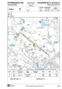
VAC chart of LFCV
 Satellite view of LFCV

Satellite view of LFCV
Sorry, we have no imagery here.
Sorry, we have no imagery here.
Sorry, we have no imagery here.
Sorry, we have no imagery here.
Sorry, we have no imagery here.
Sorry, we have no imagery here.


LFCV - Villefranche De Rouergue
Located in Villefranche De Rouergue, France
ICAO - LFCV, IATA -
Data provided by AirmateGeneral information
Coordinates: N44°22'8" E2°1'37"
Elevation is 1104 feet MSL.
Magnetic variation is 1.12° East View others Airports in Midi-Pyrénées
Operational data
Special qualification required
Current time UTC: 16:34:39
Current local time:
Weather at : LFCR - Rodez Aveyron ( 36 km )
METAR: LFCR 221630Z AUTO 30017KT 9999 SCT048 BKN056 14/07 Q1018 NOSIG
TAF: TAF AMD LFCR 221121Z 2211/2306 29010KT 9999 BKN022 TEMPO 2211/2214 -RADZ BKN010 BECMG 2214/2216 CAVOK BECMG 2223/2301 29005KT PROB30 TEMPO 2304/2306 0800 BCFG BKN002
Communications frequencies: [VIEW]
Runways:
| RWY identifier | QFU | Length (ft) | Width (ft) | Surface | LDA (ft) |
| 13 | 129° | 3379 | 262 | GRASS | 3379 |
| 31 | 309° | 3379 | 262 | GRASS | 3133 |
Airport contact information
Address: Villefranche De Rouergue France