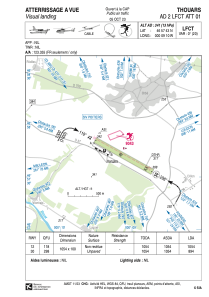
VAC chart of LFCT
 Satellite view of LFCT

Satellite view of LFCT
Sorry, we have no imagery here.
Sorry, we have no imagery here.
Sorry, we have no imagery here.
Sorry, we have no imagery here.
Sorry, we have no imagery here.


LFCT - Thouars
Located in Thouars, France
ICAO - LFCT, IATA -
Data provided by AirmateGeneral information
Coordinates: N46°57'43" W0°9'10"
Elevation is 341 feet MSL.
Magnetic variation is 0.38° East View others Airports in Poitou-Charentes
Operational data
Special qualification required
Current time UTC: 21:11:30
Current local time:
Weather at : LFBI - Poitiers Biard ( 54 km )
METAR: LFBI 212100Z AUTO 31004KT 9999 FEW043 11/09 Q1016 NOSIG
TAF: TAF LFBI 211700Z 2118/2218 30008KT 9999 BKN040 TEMPO 2118/2120 3000 SHRA SCT009 BKN012TCU BECMG 2201/2203 BKN008 BECMG 2207/2209 SCT030 TEMPO 2215/2218 32010G25KT 3000 SHRA BKN030CB
Communications frequencies: [VIEW]
Runways:
| RWY identifier | QFU | Length (ft) | Width (ft) | Surface | LDA (ft) |
| 12 | 119° | 3458 | 328 | GRASS | 3458 |
| 30 | 299° | 3458 | 328 | GRASS | 2933 |
Airport contact information
Address: Thouars France
Fuel provider

Other aviation service providers
Aviation club (not for profit)

Club Rsa Ailes Anciennes Thouarsaises
Club Rsa Ailes Anciennes Thouarsaises
ailesanciennesthouarsaises@aol.com0611920158
