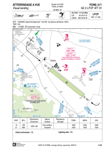
VAC chart of LFCP
 Satellite view of LFCP

Satellite view of LFCP
Sorry, we have no imagery here.
Sorry, we have no imagery here.
Sorry, we have no imagery here.
Sorry, we have no imagery here.
Sorry, we have no imagery here.
Sorry, we have no imagery here.


LFCP - Pons Avy
Located in , France
ICAO - LFCP, IATA -
Data provided by AirmateGeneral information
Coordinates: N45°33'57" W0°30'49"
Elevation is 117 feet MSL.
Magnetic variation is 0.35° East View others Airports in Poitou-Charentes
Operational data
Special qualification required
Current time UTC: 19:31:16
Current local time:
Weather at : LFBG - Cognac Chateaubernard ( 18 km )
METAR: LFBG 211900Z AUTO 33006KT 9999 FEW010/// SCT041/// BKN049/// //////TCU 14/12 Q1016 TEMPO 4000 RA BKN009 BKN020TCU BECMG 25010KT
TAF: TAF LFBG 211400Z 2115/2215 25010KT 9999 SCT015 BKN030 TEMPO 2115/2117 4000 SHRA SCT020TCU TEMPO 2117/2120 4000 RA BKN009 BKN020TCU
Communications frequencies: [VIEW]
Runways:
| RWY identifier | QFU | Length (ft) | Width (ft) | Surface | LDA (ft) |
| 13 | 129° | 4101 | 262 | GRASS | 4101 |
| 31 | 309° | 4101 | 262 | GRASS | 4101 |
Airport contact information
Address: France

