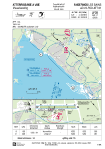
VAC chart of LFCD
 Satellite view of LFCD

Satellite view of LFCD
Sorry, we have no imagery here.
Sorry, we have no imagery here.
Sorry, we have no imagery here.
Sorry, we have no imagery here.
Sorry, we have no imagery here.
Sorry, we have no imagery here.


LFCD - Andernos Les Bains
Located in Andernos, France
ICAO - LFCD, IATA -
Data provided by AirmateGeneral information
Coordinates: N44°45'18" W1°3'54"
Elevation is 64 feet MSL.
Magnetic variation is 0.24° East View others Airports in Aquitaine
Operational data
Special qualification required
Current time UTC: 13:18:06
Current local time:
Weather at : LFBC - Cazaux ( 25 km )
METAR: LFBC 241300Z AUTO 28009KT 220V330 9999 BKN033 19/12 Q1022 NOSIG
TAF: TAF LFBC 240800Z 2409/2509 28006KT 9999 SCT030
Communications frequencies: [VIEW]
Runways:
| RWY identifier | QFU | Length (ft) | Width (ft) | Surface | LDA (ft) |
| 13 | 128° | 4068 | 197 | GRASS | 2986 |
| 31 | 308° | 4068 | 197 | GRASS | 3150 |
Airport contact information
Address: Andernos France
Fuel provider

Other aviation service providers
Aviation club (not for profit)

HELI'S COOL Héliclub du Bassin d'Arcachon
HELI'S COOL Héliclub du Bassin d'Arcachon
info@heliscool.fr+33608714287
