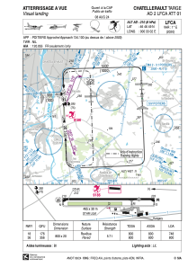
VAC chart of LFCA
 Satellite view of LFCA

Satellite view of LFCA
Sorry, we have no imagery here.
Sorry, we have no imagery here.
Sorry, we have no imagery here.
Sorry, we have no imagery here.
Sorry, we have no imagery here.


LFCA - Chatellerault Targe
Located in Chatellerault, France
ICAO - LFCA, IATA - XCX
Data provided by AirmateGeneral information
Coordinates: N46°46'49" E0°33'2"
Elevation is 210 feet MSL.
Magnetic variation is 0.60° East View others Airports in Poitou-Charentes
Operational data
Special qualification required
Current time UTC: 07:50:42
Current local time:
Weather at : LFBI - Poitiers Biard ( 28 km )
METAR: LFBI 230730Z AUTO 34006KT 300V020 CAVOK 14/11 Q1020 NOSIG
TAF: TAF LFBI 230500Z 2306/2406 31005KT CAVOK
Communications frequencies: [VIEW]
Runways:
| RWY identifier | QFU | Length (ft) | Width (ft) | Surface | LDA (ft) |
| 18 | 177° | 2625 | 66 | ASPH | 2454 |
| 36 | 357° | 2625 | 66 | ASPH | 2625 |
Airport contact information
Address: Chatellerault France
