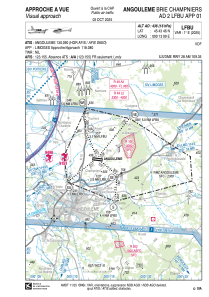
VAC chart of LFBU
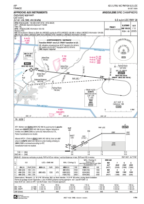
 IAC chart of LFBU
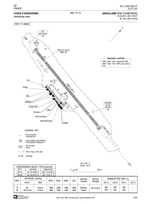
 ADC chart of LFBU
 Satellite view of LFBU

IAC chart of LFBUADC chart of LFBU
Satellite view of LFBU
Sorry, we have no imagery here.
Sorry, we have no imagery here.
Sorry, we have no imagery here.
Sorry, we have no imagery here.
Sorry, we have no imagery here.
Sorry, we have no imagery here.


LFBU - Angouleme Brie Champniers
Located in Angouleme, France
ICAO - LFBU, IATA - ANG
Data provided by AirmateGeneral information
Coordinates: N45°43'46" E0°13'9"
Elevation is 436 feet MSL.
Magnetic variation is 0.56° East View others Airports in Poitou-Charentes
Operational data
Special qualification required
Current time UTC: 03:55:54
Current local time:
Weather
METAR: LFBU 220330Z AUTO 31007KT 9999 SCT016 BKN058 10/09 Q1017
TAF: TAF LFBU 211700Z 2118/2218 25010KT 9999 BKN030 TEMPO 2118/2120 4000 -SHRA BKN008 BKN020TCU BECMG 2120/2122 31005KT PROB40 TEMPO 2201/2206 3000 BR BECMG 2206/2208 36010KT BKN010 BECMG 2208/2210 SCT020 PROB40 TEMPO 2216/2218 4500 -SHRA BKN050TCU
Communications frequencies: [VIEW]
Runways:
| RWY identifier | QFU | Length (ft) | Width (ft) | Surface | LDA (ft) |
| 10 | 97° | 6102 | 148 | ASPH | 6102 |
| 28 | 277° | 6102 | 148 | ASPH | 6102 |
Airport contact information
Address: Angouleme France
