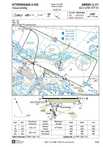
VAC chart of LFAY
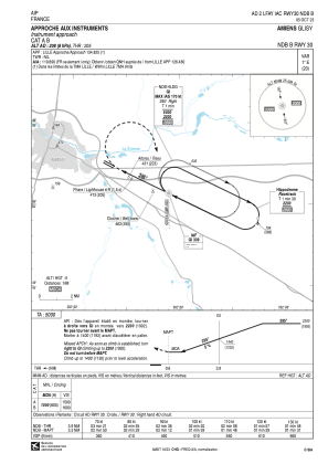
 IAC chart of LFAY
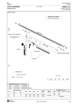
 ADC chart of LFAY
 Satellite view of LFAY

IAC chart of LFAYADC chart of LFAY
Satellite view of LFAY
Sorry, we have no imagery here.
Sorry, we have no imagery here.
Sorry, we have no imagery here.
Sorry, we have no imagery here.
Sorry, we have no imagery here.
Sorry, we have no imagery here.


LFAY - Amiens-Glisy
Located in Amiens, France
ICAO - LFAY, IATA - QAM
Data provided by AirmateGeneral information
Coordinates: N49°52'23" E2°23'13"
Elevation is 208 feet MSL.
Magnetic variation is 0.98° East View others Airports in Picardie
Operational data
Special qualification required
Current time UTC: 07:14:53
Current local time:
Weather at : LFAQ - Albert Bray ( 24 km )
METAR: LFAQ 220700Z AUTO 33011KT 9999 BKN028 11/06 Q1017 NOSIG
TAF: TAF LFAQ 220500Z 2206/2215 32008KT 9999 OVC030 PROB40 TEMPO 2213/2215 4000 SHRA SCT030TCU
Communications frequencies: [VIEW]
Runways:
| RWY identifier | QFU | Length (ft) | Width (ft) | Surface | LDA (ft) |
| 12 | 116° | 4239 | 82 | ASPH | 4239 |
| 30 | 296° | 4239 | 82 | ASPH | 4239 |
| 12R | 116° | 2953 | 328 | GRASS | 2953 |
| 30L | 296° | 2953 | 328 | GRASS | 2953 |
Airport contact information
Address: Amiens France
Handlers

Fuel provider

Other aviation service providers
Aviation club (not for profit)

Aéroclub Picardie Amiens Métropole
Aéroclub Picardie Amiens Métropole
contact@aeroclub-picardie-amiens.com+33322381070
