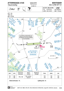
VAC chart of LFAR
 Satellite view of LFAR

Satellite view of LFAR
Sorry, we have no imagery here.
Sorry, we have no imagery here.
Sorry, we have no imagery here.
Sorry, we have no imagery here.
Sorry, we have no imagery here.
Sorry, we have no imagery here.


LFAR - Montdidier
Located in Montdidier, France
ICAO - LFAR, IATA -
Data provided by AirmateGeneral information
Coordinates: N49°40'23" E2°34'9"
Elevation is 358 feet MSL.
Magnetic variation is 1.05° East View others Airports in Picardie
Operational data
Special qualification required
Current time UTC: 08:29:01
Current local time:
Weather at : LFAQ - Albert Bray ( 34 km )
METAR: LFAQ 230800Z AUTO 33011KT 290V010 9999 BKN029 BKN035 13/05 Q1020 NOSIG
TAF: TAF LFAQ 230500Z 2306/2315 29005KT 9999 SCT040 BKN060 BECMG 2307/2309 35011KT
Communications frequencies: [VIEW]
Runways:
| RWY identifier | QFU | Length (ft) | Width (ft) | Surface | LDA (ft) |
| 09 | 86° | 2461 | 328 | GRASS | 2461 |
| 27 | 266° | 2461 | 328 | GRASS | 2461 |
Airport contact information
Address: Montdidier France

