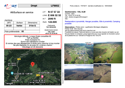
VAC chart of LF8852
 Satellite view of LF8852
Satellite view of LF8852
Sorry, we have no imagery here.
Sorry, we have no imagery here.
Sorry, we have no imagery here.
Sorry, we have no imagery here.
Sorry, we have no imagery here.
Sorry, we have no imagery here.


LF8852 - Dropt
Located in Girmont-Val-d'Ajol, France
ICAO - , IATA -
Data provided by AirmateGeneral information
Coordinates: N47°57'33" E6°32'32"
Elevation is 2040 feet MSL.
View others Airports in Lorraine
Operational data
Special qualification required
Current time UTC: 04:50:46
Current local time:
Weather at : LFSX - Luxeuil Saint Sauveur ( 23 km )
METAR: LFSX 260430Z AUTO 26004KT 9999 FEW016/// SCT023/// BKN034/// ///CB 13/12 Q1019
TAF: TAF LFSX 260415Z 2604/2703 26008KT 8000 RA SCT012 BKN030 BECMG 2605/2607 NSW SCT020
Communications frequencies: [VIEW]
Runways:
| RWY identifier | QFU | Length (ft) | Width (ft) | Surface | LDA (ft) |
| 05 | 0° | 1017 | 39 | GRASS | |
| 23 | 0° | 1017 | 39 | GRASS |
Airport contact information
Address: Girmont-Val-d'Ajol France
Satellite view of LF8852
Sorry, we have no imagery here.
Sorry, we have no imagery here.
Sorry, we have no imagery here.
Sorry, we have no imagery here.
Sorry, we have no imagery here.
Sorry, we have no imagery here.