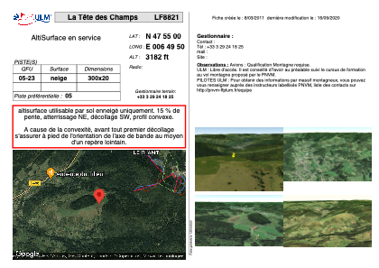
VAC chart of LF8821
 Satellite view of LF8821
Satellite view of LF8821
Sorry, we have no imagery here.
Sorry, we have no imagery here.
Sorry, we have no imagery here.
Sorry, we have no imagery here.
Sorry, we have no imagery here.
Sorry, we have no imagery here.


LF8821 - La Tête des Champs
Located in Le Menil, France
ICAO - , IATA -
Data provided by AirmateGeneral information
Coordinates: N47°54'60" E6°49'50"
Elevation is 3182 feet MSL.
View others Airports in Lorraine
Operational data
Special qualification required
Current time UTC: 08:49:14
Current local time:
Communications frequencies: [VIEW]
Runways:
| RWY identifier | QFU | Length (ft) | Width (ft) | Surface | LDA (ft) |
| 05 | 0° | 984 | 65 | SNOW | |
| 23 | 0° | 984 | 65 | SNOW |
Airport contact information
Address: Le Menil France
Satellite view of LF8821
Sorry, we have no imagery here.
Sorry, we have no imagery here.
Sorry, we have no imagery here.
Sorry, we have no imagery here.
Sorry, we have no imagery here.
Sorry, we have no imagery here.