VAC chart of LF8621
 Satellite view of LF8621

Satellite view of LF8621
Sorry, we have no imagery here.
Sorry, we have no imagery here.
Sorry, we have no imagery here.
Sorry, we have no imagery here.
Sorry, we have no imagery here.
Sorry, we have no imagery here.


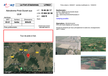
LF8621 - Le Fort d'Aslonnes
Located in Aslonnes , France
ICAO - , IATA -
Data provided by AirmateGeneral information
Coordinates: N46°26'17" E0°20'30"
Elevation is 430 feet MSL.
View others Airports in Poitou-Charentes
Operational data
Special qualification required
Current time UTC: 19:31:05
Current local time:
Weather at : LFBI - Poitiers Biard ( 17 km )
METAR: LFBI 271900Z AUTO 25009KT CAVOK 18/12 Q1023 NOSIG
TAF: TAF LFBI 271700Z 2718/2818 24009KT 9999 BKN030 TEMPO 2802/2807 4000 BR BKN008
Communications frequencies: [VIEW]
Runways:
| RWY identifier | QFU | Length (ft) | Width (ft) | Surface | LDA (ft) |
| 03 | 0° | 2624 | 98 | GRASS | |
| 21 | 0° | 2624 | 98 | GRASS |
Airport contact information
Address: Aslonnes France
Satellite view of LF8621
Sorry, we have no imagery here.
Sorry, we have no imagery here.
Sorry, we have no imagery here.
Sorry, we have no imagery here.
Sorry, we have no imagery here.
Sorry, we have no imagery here.