VAC chart of LF8529
 Satellite view of LF8529

Satellite view of LF8529
Sorry, we have no imagery here.
Sorry, we have no imagery here.
Sorry, we have no imagery here.
Sorry, we have no imagery here.
Sorry, we have no imagery here.
Sorry, we have no imagery here.


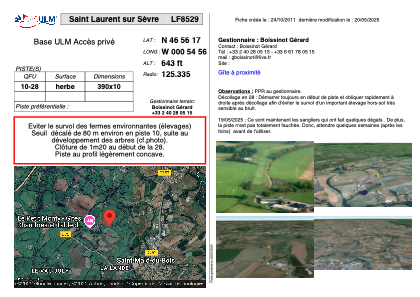
LF8529 - Saint Laurent sur Sèvre
Located in Saint-Laurent-sur-Sèvre , France
ICAO - , IATA -
Data provided by AirmateGeneral information
Coordinates: N46°56'17" W0°54'56"
Elevation is 643 feet MSL.
View others Airports in Poitou-Charentes
Operational data
Special qualification required
Current time UTC: 02:39:42
Current local time:
Weather at : LFRI - La Roche Sur Yon Les Ajoncs ( 44 km )
METAR: LFRI 220230Z AUTO 34005KT CAVOK 08/08 Q1019
TAF: TAF LFRI 211700Z 2118/2218 31008KT 9999 BKN030 TEMPO 2118/2121 3000 SHRA BKN030TCU PROB30 TEMPO 2204/2206 3000 BR TEMPO 2212/2218 29010G25KT 3000 SHRA BKN030CB
Communications frequencies: [VIEW]
Runways:
| RWY identifier | QFU | Length (ft) | Width (ft) | Surface | LDA (ft) |
| 10 | 0° | 1279 | 32 | GRASS | |
| 28 | 0° | 1279 | 32 | GRASS |
Airport contact information
Address: Saint-Laurent-sur-Sèvre France
Satellite view of LF8529
Sorry, we have no imagery here.
Sorry, we have no imagery here.
Sorry, we have no imagery here.
Sorry, we have no imagery here.
Sorry, we have no imagery here.
Sorry, we have no imagery here.