VAC chart of LF8266
 Satellite view of LF8266

Satellite view of LF8266
Sorry, we have no imagery here.
Sorry, we have no imagery here.
Sorry, we have no imagery here.
Sorry, we have no imagery here.
Sorry, we have no imagery here.


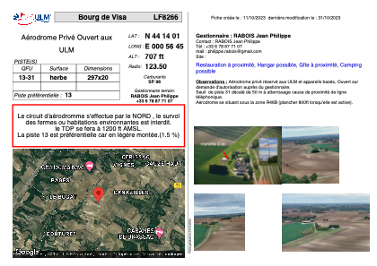
LF8266 - Bourg de Visa
Located in Bourg-de-Visa, France
ICAO - , IATA -
Data provided by AirmateGeneral information
Coordinates: N44°14'1" E0°56'45"
Elevation is 707 feet MSL.
View others Airports in Aquitaine
Operational data
Special qualification required
Current time UTC: 00:39:55
Current local time:
Weather at : LFBA - Agen La Garenne ( 29 km )
METAR: LFBA 180030Z AUTO 00000KT CAVOK 09/08 Q1015
TAF: TAF LFBA 171400Z 1715/1724 29004KT CAVOK
Communications frequencies: [VIEW]
Runways:
| RWY identifier | QFU | Length (ft) | Width (ft) | Surface | LDA (ft) |
| 13 | 0° | 974 | 65 | GRASS | |
| 31 | 0° | 974 | 65 | GRASS |
Airport contact information
Address: Bourg-de-Visa France
Satellite view of LF8266
Sorry, we have no imagery here.
Sorry, we have no imagery here.
Sorry, we have no imagery here.
Sorry, we have no imagery here.
Sorry, we have no imagery here.