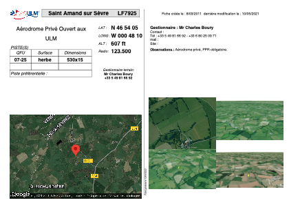
VAC chart of LF7925
 Satellite view of LF7925

Satellite view of LF7925
Sorry, we have no imagery here.
Sorry, we have no imagery here.
Sorry, we have no imagery here.
Sorry, we have no imagery here.
Sorry, we have no imagery here.
Sorry, we have no imagery here.


LF7925 - Saint Amand sur Sèvre
Located in Saint-Amand-sur-Sèvre, France
ICAO - , IATA -
Data provided by AirmateGeneral information
Coordinates: N46°54'5" W0°48'10"
Elevation is 607 feet MSL.
View others Airports in Poitou-Charentes
Operational data
Special qualification required
Current time UTC: 02:25:03
Current local time:
Weather at : LFRI - La Roche Sur Yon Les Ajoncs ( 49 km )
METAR: LFRI 210200Z AUTO 23003KT 9999 FEW017 11/10 Q1019
TAF: TAF LFRI 201700Z 2018/2118 28010KT CAVOK BECMG 2022/2024 VRB03KT PROB40 TEMPO 2100/2106 2000 BR BKN002 PROB30 TEMPO 2100/2104 0600 FG VV/// BECMG 2109/2112 27010KT PROB40 TEMPO 2112/2118 4000 -SHRA SCT030TCU
Communications frequencies: [VIEW]
Runways:
| RWY identifier | QFU | Length (ft) | Width (ft) | Surface | LDA (ft) |
| 07 | 0° | 1738 | 49 | GRASS | |
| 25 | 0° | 1738 | 49 | GRASS |
Airport contact information
Address: Saint-Amand-sur-Sèvre France
Satellite view of LF7925
Sorry, we have no imagery here.
Sorry, we have no imagery here.
Sorry, we have no imagery here.
Sorry, we have no imagery here.
Sorry, we have no imagery here.
Sorry, we have no imagery here.