VAC chart of LF7151
 Satellite view of LF7151

Satellite view of LF7151
Sorry, we have no imagery here.
Sorry, we have no imagery here.
Sorry, we have no imagery here.
Sorry, we have no imagery here.
Sorry, we have no imagery here.
Sorry, we have no imagery here.


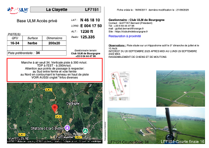
LF7151 - La Clayette
Located in Curbigny, France
ICAO - , IATA -
Data provided by AirmateGeneral information
Coordinates: N46°18'10" E4°17'50"
Elevation is 1230 feet MSL.
View others Airports in Burgundy
Operational data
Special qualification required
Current time UTC: 11:13:05
Current local time:
Weather at : LFLN - Saint Yan ( 24 km )
METAR: LFLN 211100Z AUTO 29010KT 260V330 CAVOK 20/09 Q1017 NOSIG
TAF: TAF LFLN 210800Z 2109/2118 28010KT CAVOK
Communications frequencies: [VIEW]
Runways:
| RWY identifier | QFU | Length (ft) | Width (ft) | Surface | LDA (ft) |
| 16 | 0° | 656 | 65 | GRASS | |
| 34 | 0° | 656 | 65 | GRASS |
Airport contact information
Address: Curbigny France
Satellite view of LF7151
Sorry, we have no imagery here.
Sorry, we have no imagery here.
Sorry, we have no imagery here.
Sorry, we have no imagery here.
Sorry, we have no imagery here.
Sorry, we have no imagery here.