VAC chart of LF6721
 Satellite view of LF6721
Satellite view of LF6721
Sorry, we have no imagery here.
Sorry, we have no imagery here.
Sorry, we have no imagery here.
Sorry, we have no imagery here.
Sorry, we have no imagery here.
Sorry, we have no imagery here.


LF6721 - Albé - Val de Villé
Located in Albé, France
ICAO - , IATA -
Data provided by AirmateGeneral information
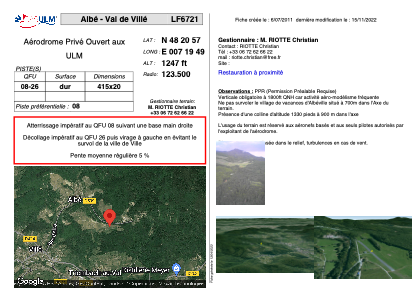
Coordinates: N48°20'57" E7°19'49"
Elevation is 1247 feet MSL.
View others Airports in Alsace
Operational data
Special qualification required
Current time UTC: 13:44:38
Current local time:
Weather at : LFGA - Colmar Houssen ( 27 km )
METAR: LFGA 241330Z AUTO VRB02KT CAVOK 20/02 Q1018
Communications frequencies: [VIEW]
Runways:
| RWY identifier | QFU | Length (ft) | Width (ft) | Surface | LDA (ft) |
| 08 | 0° | 1361 | 65 | ASPH | |
| 26 | 0° | 1361 | 65 | ASPH |
Airport contact information
Address: Albé France
Satellite view of LF6721
Sorry, we have no imagery here.
Sorry, we have no imagery here.
Sorry, we have no imagery here.
Sorry, we have no imagery here.
Sorry, we have no imagery here.
Sorry, we have no imagery here.