VAC chart of LF6715
 Satellite view of LF6715

Satellite view of LF6715
Sorry, we have no imagery here.
Sorry, we have no imagery here.
Sorry, we have no imagery here.
Sorry, we have no imagery here.
Sorry, we have no imagery here.
Sorry, we have no imagery here.


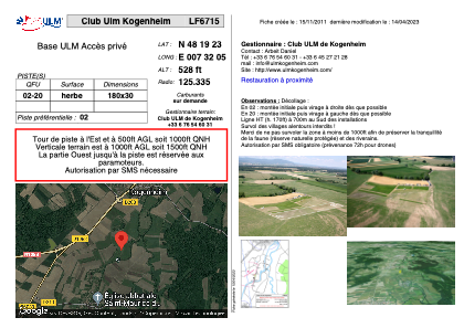
LF6715 - Club Ulm Kogenheim
Located in Kogenheim, France
ICAO - , IATA -
Data provided by AirmateGeneral information
Coordinates: N48°19'23" E7°32'5"
Elevation is 528 feet MSL.
View others Airports in Alsace
Operational data
Special qualification required
Current time UTC: 01:27:15
Current local time:
Weather at : EDTL - Lahr ( 22 km )
METAR: EDTL 230120Z AUTO VRB01KT 9999 // FEW075/// BKN100/// 11/05 Q1016
TAF: TAF EDTL 221700Z 2218/2224 32008KT CAVOK BECMG 2218/2221 VRB03KT
Communications frequencies: [VIEW]
Runways:
| RWY identifier | QFU | Length (ft) | Width (ft) | Surface | LDA (ft) |
| 02 | 0° | 590 | 98 | GRASS | |
| 20 | 0° | 590 | 98 | GRASS |
Airport contact information
Address: Kogenheim France
Satellite view of LF6715
Sorry, we have no imagery here.
Sorry, we have no imagery here.
Sorry, we have no imagery here.
Sorry, we have no imagery here.
Sorry, we have no imagery here.
Sorry, we have no imagery here.