VAC chart of LF6627
 Satellite view of LF6627

Satellite view of LF6627
Sorry, we have no imagery here.
Sorry, we have no imagery here.
Sorry, we have no imagery here.
Sorry, we have no imagery here.
Sorry, we have no imagery here.
Sorry, we have no imagery here.


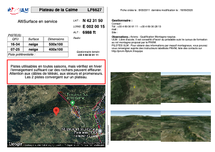
LF6627 - Plateau de la Calme
Located in Font-Romeu-Odeillo-Via, France
ICAO - , IATA -
Data provided by AirmateGeneral information
Coordinates: N42°31'50" E2°0'15"
Elevation is 6988 feet MSL.
View others Airports in Languedoc-Roussillon
Operational data
Special qualification required
Current time UTC: 14:51:45
Current local time:
Weather at : LESU - Andorra-La Seu D'urgell ( 53 km )
METAR: LESU 241430Z 23008KT 210V310 9999 SCT059 21/13 Q1015
TAF: TAF LESU 241400Z 2415/2515 VRB03KT 9999 FEW030 TX27/2515Z TN10/2505Z TEMPO 2415/2418 32010KT TEMPO 2512/2515 32010KT
Communications frequencies: [VIEW]
Runways:
| RWY identifier | QFU | Length (ft) | Width (ft) | Surface | LDA (ft) |
| 16 | 0° | 1640 | 328 | SNOW | |
| 34 | 0° | 1640 | 328 | SNOW |
Airport contact information
Address: Font-Romeu-Odeillo-Via France
Satellite view of LF6627
Sorry, we have no imagery here.
Sorry, we have no imagery here.
Sorry, we have no imagery here.
Sorry, we have no imagery here.
Sorry, we have no imagery here.
Sorry, we have no imagery here.