VAC chart of LF6623
 Satellite view of LF6623
Satellite view of LF6623
Sorry, we have no imagery here.
Sorry, we have no imagery here.
Sorry, we have no imagery here.
Sorry, we have no imagery here.
Sorry, we have no imagery here.
Sorry, we have no imagery here.


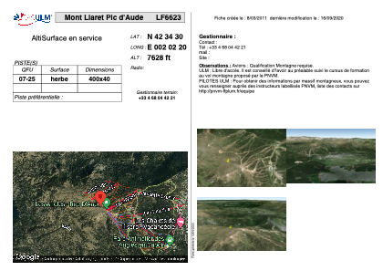
LF6623 - Mont Llaret Pic d'Aude
Located in Les Angles, France
ICAO - , IATA -
Data provided by AirmateGeneral information
Coordinates: N42°34'30" E2°2'20"
Elevation is 7628 feet MSL.
View others Airports in Languedoc-Roussillon
Operational data
Special qualification required
Current time UTC: 22:30:05
Current local time:
Weather at : LESU - Andorra-La Seu D'urgell ( 58 km )
TAF: TAF LESU 061400Z 0615/0715 20010KT 9999 FEW060 TX37/0714Z TN17/0705Z PROB40 TEMPO 0615/0618 RA FEW070TCU BECMG 0616/0618 VRB03KT BECMG 0710/0712 20010KT
Communications frequencies: [VIEW]
Runways:
| RWY identifier | QFU | Length (ft) | Width (ft) | Surface | LDA (ft) |
| 07 | 0° | 1312 | 131 | GRASS | |
| 25 | 0° | 1312 | 131 | GRASS |
Airport contact information
Address: Les Angles France
Satellite view of LF6623
Sorry, we have no imagery here.
Sorry, we have no imagery here.
Sorry, we have no imagery here.
Sorry, we have no imagery here.
Sorry, we have no imagery here.
Sorry, we have no imagery here.