VAC chart of LF6555
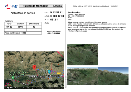 Satellite view of LF6555
Satellite view of LF6555
Sorry, we have no imagery here.
Sorry, we have no imagery here.
Sorry, we have no imagery here.
Sorry, we have no imagery here.
Sorry, we have no imagery here.
Sorry, we have no imagery here.


LF6555 - Plateau de Monhaillat
Located in Sers, France
ICAO - , IATA -
Data provided by AirmateGeneral information
Coordinates: N42°54'41" E0°7'40"
Elevation is 6312 feet MSL.
View others Airports in Midi-Pyrénées
Operational data
Special qualification required
Current time UTC: 09:45:35
Current local time:
Weather at : LFBT - Tarbes Lourdes Pyrenees ( 32 km )
METAR: LFBT 290930Z AUTO 10005KT 050V180 CAVOK 22/15 Q1025 NOSIG
TAF: TAF LFBT 290500Z 2906/3006 18004KT CAVOK BECMG 2909/2911 06008KT BECMG 2919/2921 VRB03KT
Communications frequencies: [VIEW]
Runways:
| RWY identifier | QFU | Length (ft) | Width (ft) | Surface | LDA (ft) |
| 07 | 0° | 131 | 0 | DIRT | |
| 25 | 0° | 131 | 0 | DIRT |
Airport contact information
Address: Sers France
Satellite view of LF6555
Sorry, we have no imagery here.
Sorry, we have no imagery here.
Sorry, we have no imagery here.
Sorry, we have no imagery here.
Sorry, we have no imagery here.
Sorry, we have no imagery here.