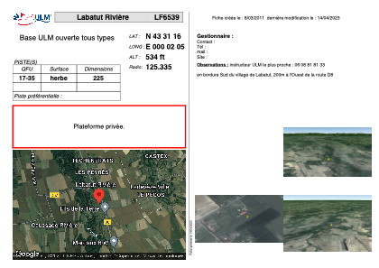
VAC chart of LF6539
 Satellite view of LF6539
Satellite view of LF6539
Sorry, we have no imagery here.
Sorry, we have no imagery here.
Sorry, we have no imagery here.
Sorry, we have no imagery here.
Sorry, we have no imagery here.
Sorry, we have no imagery here.


LF6539 - Labatut Rivière
Located in Labatut-Rivière, France
ICAO - , IATA -
Data provided by AirmateGeneral information
Coordinates: N43°31'16" E0°2'5"
Elevation is 534 feet MSL.
View others Airports in Midi-Pyrénées
Operational data
Special qualification required
Current time UTC: 13:01:14
Current local time:
Weather at : LFBT - Tarbes Lourdes Pyrenees ( 37 km )
METAR: LFBT 211230Z AUTO 31010KT 270V350 9999 BKN035 18/10 Q1020 NOSIG
TAF: TAF LFBT 211100Z 2112/2212 29011KT 9999 BKN035 TEMPO 2117/2120 SCT016TCU TEMPO 2123/2212 -RA BKN020 TEMPO 2202/2205 BKN006
Communications frequencies: [VIEW]
Runways:
| RWY identifier | QFU | Length (ft) | Width (ft) | Surface | LDA (ft) |
| 17 | 0° | 738 | 0 | GRASS | |
| 35 | 0° | 738 | 0 | GRASS |
Airport contact information
Address: Labatut-Rivière France
Satellite view of LF6539
Sorry, we have no imagery here.
Sorry, we have no imagery here.
Sorry, we have no imagery here.
Sorry, we have no imagery here.
Sorry, we have no imagery here.
Sorry, we have no imagery here.