VAC chart of LF6538
 Satellite view of LF6538

Satellite view of LF6538
Sorry, we have no imagery here.
Sorry, we have no imagery here.
Sorry, we have no imagery here.
Sorry, we have no imagery here.
Sorry, we have no imagery here.
Sorry, we have no imagery here.


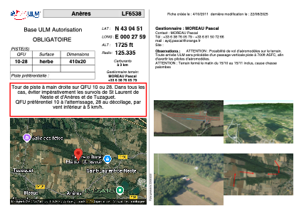
LF6538 - Anères
Located in Loures-Barousse, France
ICAO - , IATA -
Data provided by AirmateGeneral information
Coordinates: N43°4'51" E0°27'59"
Elevation is 1725 feet MSL.
View others Airports in Midi-Pyrénées
Operational data
Special qualification required
Current time UTC: 19:43:22
Current local time:
Weather at : LFBT - Tarbes Lourdes Pyrenees ( 40 km )
METAR: LFBT 251930Z AUTO 30007KT 9999 BKN100 17/07 Q1023 NOSIG
TAF: TAF LFBT 251700Z 2518/2618 28006KT CAVOK BECMG 2603/2606 BKN012 BECMG 2606/2609 BKN030 BECMG 2615/2617 SCT035
Communications frequencies: [VIEW]
Runways:
| RWY identifier | QFU | Length (ft) | Width (ft) | Surface | LDA (ft) |
| 10 | 0° | 1312 | 49 | GRASS | |
| 28 | 0° | 1312 | 49 | GRASS |
Airport contact information
Address: Loures-Barousse France
Satellite view of LF6538
Sorry, we have no imagery here.
Sorry, we have no imagery here.
Sorry, we have no imagery here.
Sorry, we have no imagery here.
Sorry, we have no imagery here.
Sorry, we have no imagery here.