VAC chart of LF6458
 Satellite view of LF6458
Satellite view of LF6458
Sorry, we have no imagery here.
Sorry, we have no imagery here.
Sorry, we have no imagery here.
Sorry, we have no imagery here.
Sorry, we have no imagery here.
Sorry, we have no imagery here.


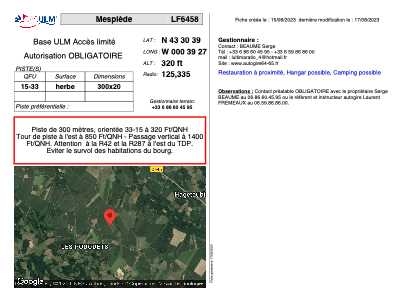
LF6458 - Mesplède
Located in Mesplede, France
ICAO - , IATA -
Data provided by AirmateGeneral information
Coordinates: N43°30'39" W0°39'27"
Elevation is 320 feet MSL.
View others Airports in Aquitaine
Operational data
Special qualification required
Current time UTC: 10:14:08
Current local time:
Weather at : LFBP - Pau Pyrenees ( 24 km )
METAR: LFBP 251000Z AUTO 25006KT 200V310 9999 SCT027 20/13 Q1021 NOSIG
TAF: TAF LFBP 250500Z 2506/2606 VRB03KT CAVOK BECMG 2510/2512 29008KT BECMG 2522/2524 VRB03KT TEMPO 2605/2606 BKN015
Communications frequencies: [VIEW]
Runways:
| RWY identifier | QFU | Length (ft) | Width (ft) | Surface | LDA (ft) |
| 15 | 0° | 984 | 65 | GRASS | |
| 33 | 0° | 984 | 65 | GRASS |
Airport contact information
Address: Mesplede France
Web: www.autogire64-65.fr
Satellite view of LF6458
Sorry, we have no imagery here.
Sorry, we have no imagery here.
Sorry, we have no imagery here.
Sorry, we have no imagery here.
Sorry, we have no imagery here.
Sorry, we have no imagery here.