VAC chart of LF6457
 Satellite view of LF6457

Satellite view of LF6457
Sorry, we have no imagery here.
Sorry, we have no imagery here.
Sorry, we have no imagery here.
Sorry, we have no imagery here.
Sorry, we have no imagery here.
Sorry, we have no imagery here.


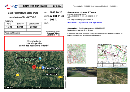
LF6457 - Saint Pée sur Nivelle
Located in Saint-Pée-sur-Nivelle, France
ICAO - , IATA -
Data provided by AirmateGeneral information
Coordinates: N43°20'20" W1°31'46"
Elevation is 302 feet MSL.
View others Airports in Aquitaine
Operational data
Special qualification required
Current time UTC: 02:32:37
Current local time:
Weather at : LFBZ - Biarritz Pays Basque ( 14 km )
METAR: LFBZ 280230Z AUTO VRB03KT 9999 FEW010 OVC016 16/14 Q1025 NOSIG
TAF: TAF LFBZ 272300Z 2800/2824 VRB03KT CAVOK BECMG 2808/2810 34010KT
Communications frequencies: [VIEW]
Runways:
| RWY identifier | QFU | Length (ft) | Width (ft) | Surface | LDA (ft) |
| 15 | 0° | 820 | 164 | GRASS | |
| 33 | 0° | 820 | 164 | GRASS |
Airport contact information
Address: Saint-Pée-sur-Nivelle France
Satellite view of LF6457
Sorry, we have no imagery here.
Sorry, we have no imagery here.
Sorry, we have no imagery here.
Sorry, we have no imagery here.
Sorry, we have no imagery here.
Sorry, we have no imagery here.