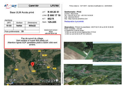
VAC chart of LF5760
 Satellite view of LF5760

Satellite view of LF5760
Sorry, we have no imagery here.
Sorry, we have no imagery here.
Sorry, we have no imagery here.
Sorry, we have no imagery here.
Sorry, we have no imagery here.
Sorry, we have no imagery here.


LF5760 - Cann'Air
Located in Inglange, France
ICAO - , IATA -
Data provided by AirmateGeneral information
Coordinates: N49°20'41" E6°17'16"
Elevation is 852 feet MSL.
View others Airports in Lorraine
Operational data
Special qualification required
Current time UTC: 17:41:18
Current local time:
Weather at : ELLX - Luxembourg ( 32 km )
METAR: ELLX 251720Z 23011KT 9999 FEW013 BKN070 14/12 Q1014 NOSIG
TAF: TAF ELLX 251700Z 2518/2624 21012KT 9999 SCT040 BECMG 2518/2521 27006KT TEMPO 2608/2618 21012KT
Communications frequencies: [VIEW]
Runways:
| RWY identifier | QFU | Length (ft) | Width (ft) | Surface | LDA (ft) |
| 15 | 0° | 1312 | 72 | GRASS | |
| 33 | 0° | 1312 | 72 | GRASS |
Airport contact information
Address: Inglange France
Satellite view of LF5760
Sorry, we have no imagery here.
Sorry, we have no imagery here.
Sorry, we have no imagery here.
Sorry, we have no imagery here.
Sorry, we have no imagery here.
Sorry, we have no imagery here.