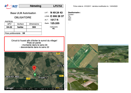
VAC chart of LF5753
 Satellite view of LF5753

Satellite view of LF5753
Sorry, we have no imagery here.
Sorry, we have no imagery here.
Sorry, we have no imagery here.
Sorry, we have no imagery here.
Sorry, we have no imagery here.
Sorry, we have no imagery here.


LF5753 - Rémeling
Located in Rémeling, France
ICAO - , IATA -
Data provided by AirmateGeneral information
Coordinates: N49°24'43" E6°28'37"
Elevation is 1017 feet MSL.
View others Airports in Lorraine
Operational data
Special qualification required
Current time UTC: 01:45:40
Current local time:
Weather at : ELLX - Luxembourg ( 31 km )
METAR: ELLX 210120Z AUTO 01009KT 9999 OVC069/// 14/06 Q1015 NOSIG
TAF: TAF ELLX 202300Z 2100/2206 03006KT CAVOK
Communications frequencies: [VIEW]
Runways:
| RWY identifier | QFU | Length (ft) | Width (ft) | Surface | LDA (ft) |
| 04 | 0° | 984 | 0 | GRASS | |
| 22 | 0° | 984 | 0 | GRASS |
Airport contact information
Address: Rémeling France
Satellite view of LF5753
Sorry, we have no imagery here.
Sorry, we have no imagery here.
Sorry, we have no imagery here.
Sorry, we have no imagery here.
Sorry, we have no imagery here.
Sorry, we have no imagery here.