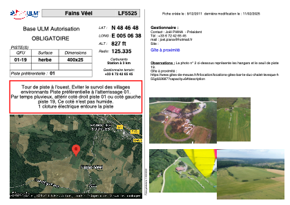
VAC chart of LF5525
 Satellite view of LF5525

Satellite view of LF5525
Sorry, we have no imagery here.
Sorry, we have no imagery here.
Sorry, we have no imagery here.
Sorry, we have no imagery here.
Sorry, we have no imagery here.
Sorry, we have no imagery here.


LF5525 - Fains Véel
Located in Fains-Veel, France
ICAO - , IATA -
Data provided by AirmateGeneral information
Coordinates: N48°46'48" E5°6'38"
Elevation is 827 feet MSL.
View others Airports in Lorraine
Operational data
Special qualification required
Current time UTC: 02:03:47
Current local time:
Weather at : LFSI - Saint Dizier Robinson ( 22 km )
METAR: LFSI 220200Z AUTO 27005KT 9999 FEW006 SCT014 OVC080 11/10 Q1012
TAF: TAF LFSI 212000Z 2121/2221 33005KT CAVOK BECMG 2204/2205 BKN009 BECMG 2206/2208 NSC
Communications frequencies: [VIEW]
Runways:
| RWY identifier | QFU | Length (ft) | Width (ft) | Surface | LDA (ft) |
| 01 | 0° | 1312 | 82 | GRASS | |
| 19 | 0° | 1312 | 82 | GRASS |
Airport contact information
Address: Fains-Veel France
Satellite view of LF5525
Sorry, we have no imagery here.
Sorry, we have no imagery here.
Sorry, we have no imagery here.
Sorry, we have no imagery here.
Sorry, we have no imagery here.
Sorry, we have no imagery here.