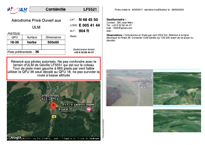
VAC chart of LF5521
 Satellite view of LF5521

Satellite view of LF5521
Sorry, we have no imagery here.
Sorry, we have no imagery here.
Sorry, we have no imagery here.
Sorry, we have no imagery here.
Sorry, we have no imagery here.
Sorry, we have no imagery here.


LF5521 - Corniéville
Located in Géville, France
ICAO - , IATA -
Data provided by AirmateGeneral information
Coordinates: N48°45'50" E5°41'44"
Elevation is 904 feet MSL.
View others Airports in Lorraine
Operational data
Special qualification required
Current time UTC: 14:29:40
Current local time:
Weather at : LFSO - Nancy Ochey ( 28 km )
METAR: LFSO 281400Z AUTO 23016KT 9999 OVC009 14/14 Q1021 TEMPO 28015G30KT 1000 TSRA BKN010 BKN020CB
TAF: TAF LFSO 280800Z 2809/2909 23010G20KT 9999 BKN008 OVC012 TEMPO 2809/2811 4500 -RADZ BKN004 BKN012 OVC015 BECMG 2813/2814 BKN020 PROB40 TEMPO 2814/2818 28015G30KT 1000 TSRA BKN010 BKN020CB BECMG 2820/2822 29010KT CAVOK BECMG 2900/2902 23005KT
Communications frequencies: [VIEW]
Runways:
| RWY identifier | QFU | Length (ft) | Width (ft) | Surface | LDA (ft) |
| 18 | 0° | 1640 | 196 | GRASS | |
| 36 | 0° | 1640 | 196 | GRASS |
Airport contact information
Address: Géville France
Satellite view of LF5521
Sorry, we have no imagery here.
Sorry, we have no imagery here.
Sorry, we have no imagery here.
Sorry, we have no imagery here.
Sorry, we have no imagery here.
Sorry, we have no imagery here.