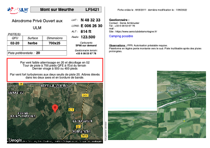
VAC chart of LF5421
 Satellite view of LF5421

Satellite view of LF5421
Sorry, we have no imagery here.
Sorry, we have no imagery here.
Sorry, we have no imagery here.
Sorry, we have no imagery here.
Sorry, we have no imagery here.
Sorry, we have no imagery here.


LF5421 - Mont sur Meurthe
Located in Mont-sur-Meurthe, France
ICAO - , IATA -
Data provided by AirmateGeneral information
Coordinates: N48°32'33" E6°26'30"
Elevation is 814 feet MSL.
View others Airports in Lorraine
Operational data
Special qualification required
Current time UTC: 22:19:27
Current local time:
Weather at : LFSN - Nancy Essey ( 23 km )
METAR: LFSN 312200Z AUTO 07003KT 040V100 9999 VCTS ///CB 19/16 Q1017
Communications frequencies: [VIEW]
Runways:
| RWY identifier | QFU | Length (ft) | Width (ft) | Surface | LDA (ft) |
| 02 | 0° | 2296 | 82 | GRASS | |
| 20 | 0° | 2296 | 82 | GRASS |
Airport contact information
Address: Mont-sur-Meurthe France
Satellite view of LF5421
Sorry, we have no imagery here.
Sorry, we have no imagery here.
Sorry, we have no imagery here.
Sorry, we have no imagery here.
Sorry, we have no imagery here.
Sorry, we have no imagery here.