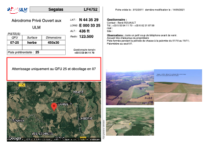
VAC chart of LF4752
 Satellite view of LF4752
Satellite view of LF4752
Sorry, we have no imagery here.
Sorry, we have no imagery here.
Sorry, we have no imagery here.
Sorry, we have no imagery here.
Sorry, we have no imagery here.
Sorry, we have no imagery here.


LF4752 - Segalas
Located in Ségalas, France
ICAO - , IATA -
Data provided by AirmateGeneral information
Coordinates: N44°35'29" E0°33'25"
Elevation is 436 feet MSL.
View others Airports in Aquitaine
Operational data
Special qualification required
Current time UTC: 05:09:09
Current local time:
Weather at : LFBE - Bergerac Dordogne Perigord ( 26 km )
METAR: LFBE 230500Z AUTO 30003KT 270V340 4300 BR OVC003 13/12 Q1020 TEMPO 0800 FG VV///
TAF: TAF AMD LFBE 230301Z 2303/2324 28005KT CAVOK TEMPO 2303/2308 4000 BR BKN002 PROB30 2303/2307 0800 FG VV/// BECMG 2310/2312 32010KT
Communications frequencies: [VIEW]
Runways:
| RWY identifier | QFU | Length (ft) | Width (ft) | Surface | LDA (ft) |
| 07 | 0° | 1476 | 98 | GRASS | |
| 25 | 0° | 1476 | 98 | GRASS |
Airport contact information
Address: Ségalas France
Satellite view of LF4752
Sorry, we have no imagery here.
Sorry, we have no imagery here.
Sorry, we have no imagery here.
Sorry, we have no imagery here.
Sorry, we have no imagery here.
Sorry, we have no imagery here.