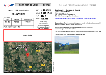
VAC chart of LF4737
 Satellite view of LF4737

Satellite view of LF4737
Sorry, we have no imagery here.
Sorry, we have no imagery here.
Sorry, we have no imagery here.
Sorry, we have no imagery here.
Sorry, we have no imagery here.
Sorry, we have no imagery here.


LF4737 - Saint Jean de Duras
Located in Saint-Jean-de-Duras, France
ICAO - , IATA -
Data provided by AirmateGeneral information
Coordinates: N44°42'29" E0°17'49"
Elevation is 410 feet MSL.
View others Airports in Aquitaine
Operational data
Special qualification required
Current time UTC: 08:37:57
Current local time:
Weather at : LFBE - Bergerac Dordogne Perigord ( 22 km )
METAR: LFBE 240830Z AUTO 29005KT 250V330 9999 BKN018 16/13 Q1022 NOSIG
TAF: TAF LFBE 240500Z 2406/2506 VRB02KT CAVOK TEMPO 2406/2408 3000 BR BKN010 PROB30 TEMPO 2406/2407 0600 FG BECMG 2417/2419 28010KT BECMG 2501/2503 VRB02KT TEMPO 2503/2506 3000 BR
Communications frequencies: [VIEW]
Runways:
| RWY identifier | QFU | Length (ft) | Width (ft) | Surface | LDA (ft) |
| 07 | 0° | 557 | 131 | GRASS | |
| 25 | 0° | 557 | 131 | GRASS |
Airport contact information
Address: Saint-Jean-de-Duras France
Satellite view of LF4737
Sorry, we have no imagery here.
Sorry, we have no imagery here.
Sorry, we have no imagery here.
Sorry, we have no imagery here.
Sorry, we have no imagery here.
Sorry, we have no imagery here.