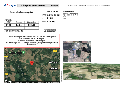
VAC chart of LF4736
 Satellite view of LF4736

Satellite view of LF4736
Sorry, we have no imagery here.
Sorry, we have no imagery here.
Sorry, we have no imagery here.
Sorry, we have no imagery here.
Sorry, we have no imagery here.
Sorry, we have no imagery here.


LF4736 - Lévignac de Guyenne
Located in Levignac-de-Guyenne, France
ICAO - , IATA -
Data provided by AirmateGeneral information
Coordinates: N44°37'10" E0°13'53"
Elevation is 213 feet MSL.
View others Airports in Aquitaine
Operational data
Special qualification required
Current time UTC: 20:32:10
Current local time:
Weather at : LFBE - Bergerac Dordogne Perigord ( 32 km )
METAR: LFBE 232000Z AUTO 27007KT CAVOK 16/09 Q1021 NOSIG
TAF: TAF LFBE 231100Z 2312/2412 29008KT 9999 BKN030 TEMPO 2312/2315 SHRA BKN030TCU PROB30 TEMPO 2403/2407 0600 FG
Communications frequencies: [VIEW]
Runways:
| RWY identifier | QFU | Length (ft) | Width (ft) | Surface | LDA (ft) |
| 01 | 0° | 1640 | 65 | GRASS | |
| 19 | 0° | 1640 | 65 | GRASS |
Airport contact information
Address: Levignac-de-Guyenne France
Satellite view of LF4736
Sorry, we have no imagery here.
Sorry, we have no imagery here.
Sorry, we have no imagery here.
Sorry, we have no imagery here.
Sorry, we have no imagery here.
Sorry, we have no imagery here.