VAC chart of LF4730
 Satellite view of LF4730

Satellite view of LF4730
Sorry, we have no imagery here.
Sorry, we have no imagery here.
Sorry, we have no imagery here.
Sorry, we have no imagery here.
Sorry, we have no imagery here.
Sorry, we have no imagery here.


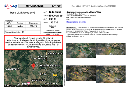
LF4730 - MIROND'AILES
Located in Miramont-de-Guyenne, France
ICAO - , IATA -
Data provided by AirmateGeneral information
Coordinates: N44°35'57" E0°20'29"
Elevation is 249 feet MSL.
View others Airports in Aquitaine
Operational data
Special qualification required
Current time UTC: 06:09:33
Current local time:
Weather at : LFBE - Bergerac Dordogne Perigord ( 29 km )
METAR: LFBE 250600Z AUTO 00000KT CAVOK 11/11 Q1021 TEMPO 1500 MIFG
TAF: TAF LFBE 250500Z 2506/2606 31003KT 8000 SCT020 TEMPO 2506/2507 1500 MIFG TEMPO 2516/2520 -SHRA PROB30 TEMPO 2518/2522 BKN010 TEMPO 2604/2606 MIFG
Communications frequencies: [VIEW]
Runways:
| RWY identifier | QFU | Length (ft) | Width (ft) | Surface | LDA (ft) |
| 13 | 0° | 820 | 65 | GRASS | |
| 31 | 0° | 820 | 65 | GRASS |
Airport contact information
Address: Miramont-de-Guyenne France
Satellite view of LF4730
Sorry, we have no imagery here.
Sorry, we have no imagery here.
Sorry, we have no imagery here.
Sorry, we have no imagery here.
Sorry, we have no imagery here.
Sorry, we have no imagery here.