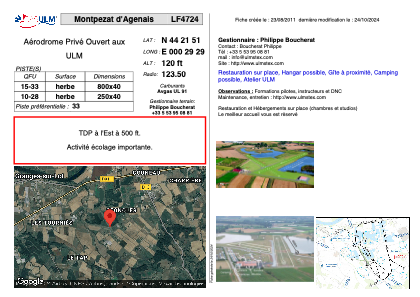
VAC chart of LF4724
 Satellite view of LF4724

Satellite view of LF4724
Sorry, we have no imagery here.
Sorry, we have no imagery here.
Sorry, we have no imagery here.
Sorry, we have no imagery here.
Sorry, we have no imagery here.
Sorry, we have no imagery here.


LF4724 - Montpezat d'Agenais
Located in Montpezat, France
ICAO - , IATA -
Data provided by AirmateGeneral information
Coordinates: N44°21'51" E0°29'29"
Elevation is 120 feet MSL.
View others Airports in Aquitaine
Operational data
Special qualification required
Current time UTC: 15:16:16
Current local time:
Weather at : LFBA - Agen La Garenne ( 22 km )
METAR: LFBA 241500Z AUTO 30006KT 250V330 CAVOK 22/10 Q1021 NOSIG
TAF: TAF LFBA 241400Z 2415/2424 32006KT CAVOK BECMG 2419/2421 VRB03KT
Communications frequencies: [VIEW]
Runways:
| RWY identifier | QFU | Length (ft) | Width (ft) | Surface | LDA (ft) |
| 15 | 0° | 2624 | 131 | GRASS | |
| 33 | 0° | 2624 | 131 | GRASS |
Airport contact information
Address: Montpezat France
