VAC chart of LF3761
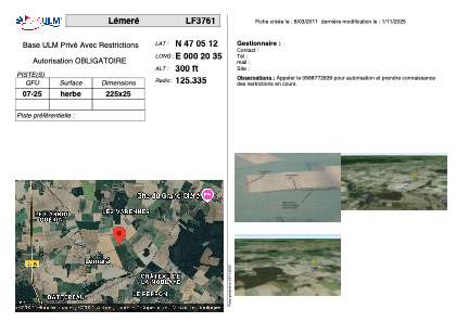 Satellite view of LF3761

Satellite view of LF3761
Sorry, we have no imagery here.
Sorry, we have no imagery here.
Sorry, we have no imagery here.
Sorry, we have no imagery here.
Sorry, we have no imagery here.
Sorry, we have no imagery here.


LF3761 - Lémeré
Located in Lémeré, France
ICAO - , IATA -
Data provided by AirmateGeneral information
Coordinates: N47°5'12" E0°20'35"
Elevation is 300 feet MSL.
View others Airports in Poitou-Charentes
Operational data
Special qualification required
Current time UTC: 20:06:43
Current local time:
Weather at : LFOT - Tours Val De Loire ( 48 km )
METAR: LFOT 242000Z AUTO 26007KT CAVOK 18/09 Q1018 NOSIG
TAF: TAF LFOT 241700Z 2418/2518 26011KT CAVOK BECMG 2422/2424 BKN015 TEMPO 2504/2512 -RA BKN012 PROB40 TEMPO 2510/2513 4000 RA SCT010 BKN020TCU BECMG 2513/2515 SCT030 SCT060
Communications frequencies: [VIEW]
Runways:
| RWY identifier | QFU | Length (ft) | Width (ft) | Surface | LDA (ft) |
| 07 | 0° | 738 | 82 | GRASS | |
| 25 | 0° | 738 | 82 | GRASS |
Airport contact information
Address: Lémeré France
Satellite view of LF3761
Sorry, we have no imagery here.
Sorry, we have no imagery here.
Sorry, we have no imagery here.
Sorry, we have no imagery here.
Sorry, we have no imagery here.
Sorry, we have no imagery here.