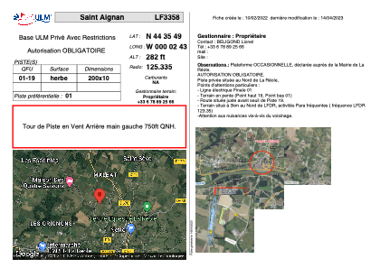
VAC chart of LF3358
 Satellite view of LF3358

Satellite view of LF3358
Sorry, we have no imagery here.
Sorry, we have no imagery here.
Sorry, we have no imagery here.
Sorry, we have no imagery here.
Sorry, we have no imagery here.
Sorry, we have no imagery here.


LF3358 - Saint Aignan
Located in La Réole, France
ICAO - , IATA -
Data provided by AirmateGeneral information
Coordinates: N44°35'49" W0°2'43"
Elevation is 282 feet MSL.
View others Airports in Aquitaine
Operational data
Special qualification required
Current time UTC: 17:56:15
Current local time:
Weather at : LFBE - Bergerac Dordogne Perigord ( 51 km )
METAR: LFBE 211730Z AUTO 24009KT 210V280 9999 -RA FEW007 BKN014 BKN021 16/14 Q1016 TEMPO 4000 -SHRA BKN010 BKN020TCU
TAF: TAF LFBE 211100Z 2112/2212 25010KT 9999 BKN025 TEMPO 2114/2123 4000 -SHRA BKN010 BKN020TCU TEMPO 2123/2206 3000 BR BKN010 BECMG 2206/2208 32010KT
Communications frequencies: [VIEW]
Runways:
| RWY identifier | QFU | Length (ft) | Width (ft) | Surface | LDA (ft) |
| 01 | 0° | 656 | 32 | GRASS | |
| 19 | 0° | 656 | 32 | GRASS |
Airport contact information
Address: La Réole France
Satellite view of LF3358
Sorry, we have no imagery here.
Sorry, we have no imagery here.
Sorry, we have no imagery here.
Sorry, we have no imagery here.
Sorry, we have no imagery here.
Sorry, we have no imagery here.