VAC chart of LF3356
 Satellite view of LF3356

Satellite view of LF3356
Sorry, we have no imagery here.
Sorry, we have no imagery here.
Sorry, we have no imagery here.
Sorry, we have no imagery here.
Sorry, we have no imagery here.
Sorry, we have no imagery here.


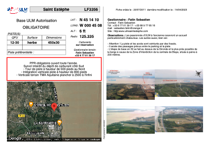
LF3356 - Saint Estèphe
Located in Saint-Estèphe, France
ICAO - , IATA -
Data provided by AirmateGeneral information
Coordinates: N45°14'10" W0°45'8"
Elevation is 6 feet MSL.
View others Airports in Aquitaine
Operational data
Special qualification required
Current time UTC: 20:16:02
Current local time:
Weather at : LFBD - Bordeaux Merignac ( 45 km )
METAR: LFBD 282000Z AUTO 33005KT 310V010 CAVOK 18/13 Q1027 NOSIG
TAF: TAF LFBD 281700Z 2818/2924 30008KT CAVOK TX29/2915Z TN14/2906Z PROB40 2900/2906 2000 MIFG PROB40 TEMPO 2902/2906 0500 FG TEMPO 2906/2908 BKN008
Communications frequencies: [VIEW]
Runways:
| RWY identifier | QFU | Length (ft) | Width (ft) | Surface | LDA (ft) |
| 12 | 0° | 1476 | 98 | GRASS | |
| 30 | 0° | 1476 | 98 | GRASS |
Airport contact information
Address: Saint-Estèphe France
Satellite view of LF3356
Sorry, we have no imagery here.
Sorry, we have no imagery here.
Sorry, we have no imagery here.
Sorry, we have no imagery here.
Sorry, we have no imagery here.
Sorry, we have no imagery here.