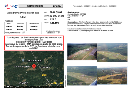
VAC chart of LF3327
 Satellite view of LF3327
Satellite view of LF3327
Sorry, we have no imagery here.
Sorry, we have no imagery here.
Sorry, we have no imagery here.
Sorry, we have no imagery here.
Sorry, we have no imagery here.
Sorry, we have no imagery here.


LF3327 - Sainte Hélène
Located in Sainte-Hélène, France
ICAO - , IATA -
Data provided by AirmateGeneral information
Coordinates: N44°59'2" W0°54'28"
Elevation is 121 feet MSL.
View others Airports in Aquitaine
Operational data
Special qualification required
Current time UTC: 21:21:25
Current local time:
Weather at : LFBD - Bordeaux Merignac ( 23 km )
METAR: LFBD 222100Z AUTO 29004KT 260V330 CAVOK 14/11 Q1022 NOSIG
TAF: TAF LFBD 221700Z 2218/2324 32010KT CAVOK TX22/2314Z TN11/2400Z BECMG 2221/2223 26005KT TEMPO 2310/2314 4000 -SHRA BKN045TCU PROB30 TEMPO 2310/2312 2000 TSRA BKN030CB BECMG 2310/2312 30010KT BECMG 2321/2323 26005KT
Communications frequencies: [VIEW]
Runways:
| RWY identifier | QFU | Length (ft) | Width (ft) | Surface | LDA (ft) |
| 09 | 0° | 984 | 65 | GRASS | |
| 27 | 0° | 984 | 65 | GRASS |
Airport contact information
Address: Sainte-Hélène France
Satellite view of LF3327
Sorry, we have no imagery here.
Sorry, we have no imagery here.
Sorry, we have no imagery here.
Sorry, we have no imagery here.
Sorry, we have no imagery here.
Sorry, we have no imagery here.