VAC chart of LF3256
 Satellite view of LF3256

Satellite view of LF3256
Sorry, we have no imagery here.
Sorry, we have no imagery here.
Sorry, we have no imagery here.
Sorry, we have no imagery here.
Sorry, we have no imagery here.
Sorry, we have no imagery here.


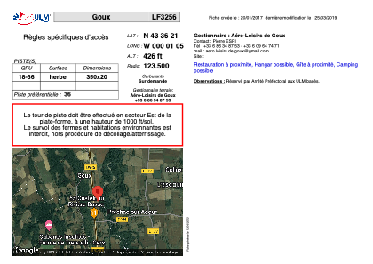
LF3256 - Goux
Located in Préchac-sur-Adour, France
ICAO - , IATA -
Data provided by AirmateGeneral information
Coordinates: N43°36'21" W0°1'5"
Elevation is 426 feet MSL.
View others Airports in Midi-Pyrénées
Operational data
Special qualification required
Current time UTC: 12:33:10
Current local time:
Weather at : LFBP - Pau Pyrenees ( 41 km )
METAR: LFBP 281230Z AUTO 34009KT 300V030 9999 BKN037 24/14 Q1026 NOSIG
TAF: TAF LFBP 281100Z 2812/2912 VRB03KT CAVOK PROB30 TEMPO 2903/2906 4000 MIFG BECMG 2910/2912 08010KT
Communications frequencies: [VIEW]
Runways:
| RWY identifier | QFU | Length (ft) | Width (ft) | Surface | LDA (ft) |
| 18 | 0° | 1148 | 65 | GRASS | |
| 36 | 0° | 1148 | 65 | GRASS |
Airport contact information
Address: Préchac-sur-Adour France
Satellite view of LF3256
Sorry, we have no imagery here.
Sorry, we have no imagery here.
Sorry, we have no imagery here.
Sorry, we have no imagery here.
Sorry, we have no imagery here.
Sorry, we have no imagery here.