VAC chart of LF2469
 Satellite view of LF2469

Satellite view of LF2469
Sorry, we have no imagery here.
Sorry, we have no imagery here.
Sorry, we have no imagery here.
Sorry, we have no imagery here.
Sorry, we have no imagery here.
Sorry, we have no imagery here.


LF2469 - Campsegret
Located in Campsegret, France
ICAO - , IATA -
Data provided by AirmateGeneral information
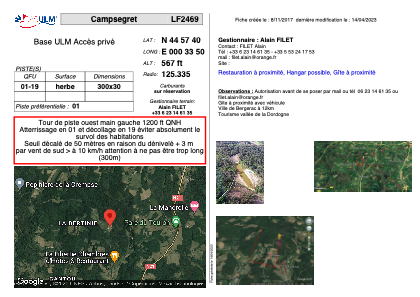
Coordinates: N44°57'40" E0°33'50"
Elevation is 567 feet MSL.
View others Airports in Aquitaine
Operational data
Special qualification required
Current time UTC: 06:39:51
Current local time:
Weather at : LFBE - Bergerac Dordogne Perigord ( 16 km )
METAR: LFBE 280630Z AUTO VRB01KT CAVOK 15/13 Q1025 NOSIG
TAF: TAF LFBE 280500Z 2806/2906 VRB03KT 8000 NSC PROB30 TEMPO 2806/2807 4000 BR TEMPO 2902/2906 3000 BR NSC PROB40 TEMPO 2902/2906 0800 FG VV///
Communications frequencies: [VIEW]
Runways:
| RWY identifier | QFU | Length (ft) | Width (ft) | Surface | LDA (ft) |
| 01 | 0° | 984 | 98 | GRASS | |
| 19 | 0° | 984 | 98 | GRASS |
Airport contact information
Address: Campsegret France
Satellite view of LF2469
Sorry, we have no imagery here.
Sorry, we have no imagery here.
Sorry, we have no imagery here.
Sorry, we have no imagery here.
Sorry, we have no imagery here.
Sorry, we have no imagery here.